Search:
Arne and Middlebere Heath
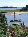
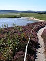
Along the southern and western sides of Poole Harbour are extensive marshes, reed-beds and lowland heath which are designated as internationally important wintering sites for waders and wildfowl. The Arne peninsula is managed as a reserve by The Royal Society for the Protection of Birds, the heathland to the south and west are managed by English Nature.
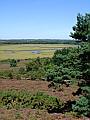
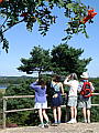
From the lookout hill on Arne near Shipstal Point (SY 983 885) there are extensive views across the harbour to Upton and Hamworthy in the north, Brownsea Island in the east, Corfe Castle and Purbeck in the south. Hard though it is to imagine, beneath this large tract of wilderness lies the largest onshore oilfield in Europe – the unobtrusiveness of the extraction operation a testimony to the environmental sensistivity with which it is being exploited.
|
|
|
|

|
|
|

|

|
|
|
To view any image full size - simply click on the thumbnail
| ||||
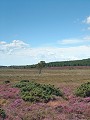
Heathland like that shown here once used to cover large parts of Dorset and – although pleasant to look at – can be treacherous terrain to try and cross (Middlebere Heath is the real life location for Hardy's fictional Egdon Heath). Hidden amongst the grass tufts and sphagnum moss filled pools on this particular heath can be found Sundews (Drosera intermedia) – here dissolving and digesting two Damsel flies caught on their sticky pads – and Marsh Gentians (Gentiana pneumonathe).
Find out more ... |
|
In the top row of pictures:
In the bottom row of pictures:
See also: Arne at twilight, Canford Heath and Holt Heath Arne also features in the monthly galleries August 2002 and April 2003 Nearby locations that also feature in galleries on this site:
More views of Dorset in August Other sites on the webThe Countryside Management site of Surrey County Council has an introduction to lowland heath on their 'Heathland > Heathland Basics' page English Nature: site giving an overview of the work and function of the organisation, with contact details for the Dorset Team. Bestwall Quarry Archaeology Project: ongoing excavations in the gravel quarry between Wareham and the Arne peninsula, with finds ranging from the Mesolithic right through to Post-Medieval The Dorset Page: Arne – local information and links to further resources on the web Maps of the area on streetmap.co.uk: 1:50,000 – detail, 1:250,000 – locality and route to get there
|