location where the photographs were taken
find out morefind out more

  Search:

Powerstock

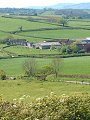
A mid-May tour around the many small hillocks and valleys to the north-east of Bridport. The geology of the area – with hard Greensands capping much softer rocks beneath – has resulted in deeply incised valleys that weave and snake their way almost at random! Not the easiest of areas to cycle around, good brakes are essential, excellent views of the scenery at many places throughout the area make the effort worthwhile though.


106-01 Powerstock 106-02 Powerstock 106-03 Powerstock 106-04 Powerstock 106-05 Powerstock
106-06 Powerstock 106-07 Powerstock 106-08 Powerstock 106-09 Powerstock 106-10 Powerstock
To view any image full size - simply click on the thumbnail
  

Find out more ...

In the top row of pictures:

  • North Poorton (picture)
  • Looking across the fields towards South Poorton from North Poorton church (picture)
  • Bluebells lining the lanes north of Hooke Park (picture)
  • Approaching Mapperton, Marsh Farm (picture)
  • Near Loscombe, Pen Well Hill and Charity Farm (picture)

In the bottom row of pictures:

  • The view at West Milton up-valley towards Powerstock, Eggardon Hill (247m) in the distance (picture)
  • Powerstock (picture)
  • Powerstock (picture)
  • Powerstock (picture)
  • Church of St Mary, Powerstock (picture)

Nearby locations that also feature in galleries on this site:

directionKingcombe, Beaminster

directionFrampton and Bradford Peverell

directionBridport

More views of Dorset in May


Other sites on the web

The Dorset Page:   Powerstock – local information and links to further resources on the web

Maps of the area on streetmap.co.uk:   1:50,000 – detail, 1:250,000 – locality and route to get there

picture resolution
The pictures of Powerstock in this gallery were captured at high resolution.
This is images of dorset stock photography gallery 106
All photographs copyright © 1998–2003 John Allen


top of page