location where the photographs were taken
find out morefind out more

  Search:

Beaminster

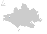
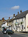
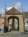
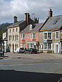
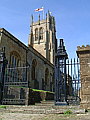
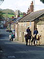
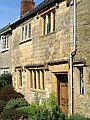
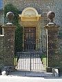
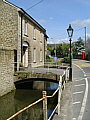
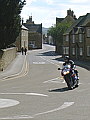
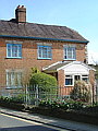
Beaminster is situated in the north-west of the county in a valley basin at the head of the river Britt and surrounded by 100–150m high hills. A small town that has managed to retain many of its pre-1900 buildings and consequently is another fine window into Dorset's architectural past. The golden yellow of the local limestone adding a warmth to the visual elements, enhanced in the scenes shown here by the crisp brightness of a showery day in April.


078-01 Beaminster 078-02 Beaminster 078-03 Beaminster 078-04 Beaminster 078-05 Beaminster
078-06 Beaminster 078-07 Beaminster 078-08 Beaminster 078-09 Beaminster 078-10 Beaminster
To view any image full size - simply click on the thumbnail
  

Find out more ...

In the top row of pictures:

  • The Square, Beaminster (picture)
  • Memorial in The Square, on the site of the market cross, memorial erected in 1906 (picture)
  • The Square (picture)
  • Church of St Mary, the tower is c. 1503 (picture)
  • Looking back into the town from the a lane on the eastern side (picture)

In the bottom row of pictures:

  • Typical limestone frontage (picture)
  • One of the more ornate doorways in the town (picture)
  • One of several stream running through the town (picture)
  • Looking back into the town from the western side (picture)
  • The southern approach (picture)

Nearby locations that also feature in galleries on this site:

directionEvershot, Kingcombe

directionPowerstock, Bridport

directionMarshwood Vale

More views of Dorset in April


Other sites on the web

The Dorset Page:   Beaminster – local information and links to further resources on the web

Maps of the area on streetmap.co.uk:   1:50,000 – detail, 1:250,000 – locality and route to get there

picture resolution
The pictures of Beaminster in this gallery were captured at medium resolution.
This is images of dorset stock photography gallery 078
All photographs copyright © 1998–2003 John Allen


top of page