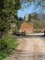
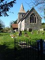
location where the photographs were taken
find out morefind out more

  Search:

Pentridge

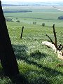
A chilly early April walk around the remote north-east corner of the county. Very few visitors come to this area, yet it is littered with the mounds and ditches left by inhabitants who once farmed and hunted in this area during Saxon, Roman, Iron Age and Neolithic times – encompassing over 5,000 years of history.

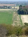
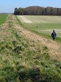
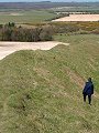
The two most prominent features are: the linear raised mound or agger of the Roman road Ackling Dyke which follows a near perfect straight line course towards Salisbury in the north-east, the sinuous mound and ditch of Bokerley Dyke – along which the current county boundary runs – used first by Iron Age then the post-Roman peoples of the area in their efforts to keep out invaders from the east.


104-01 Pentridge 104-02 Pentridge 104-03 Pentridge 104-04 Pentridge 104-05 Pentridge
104-06 Pentridge 104-07 Pentridge 104-08 Pentridge 104-09 Pentridge 104-10 Pentridge
To view any image full size - simply click on the thumbnail

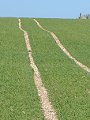
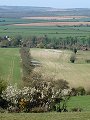
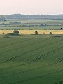
Less easily seen due to wartime ploughing – but sometimes very obvious in crop marks – the twin parallel ditches (some 90m apart) of the Dorset Cursus. Some 9km long, this Neolithic causeway runs from Long Crichel in the south-west to just short of Bokerley Dyke. Excavations of one of the ditches give dates of around 3,300BC for its construction. Its purpose – unknown.


Find out more ...

In the top row of pictures:

  • Looking north-eastwards along Ackling Dyke (Roman road) from where it crosses the B3081 near Sixpenny Handley (picture)
  • The agger of Ackling Dyke is particularly well preserved in this section, despite being nearly 2,000 years old (picture)
  • The small kink in the tractor ruts reveal a slight linear mound running left-right across the picture – the now almost ploughed-out course of the Dorset Cursus across this field near Pentridge (picture)
  • Approaching Pentridge from the south-west (picture)
  • Pentridge, Church of St Rumbold, built 1855 (picture)

In the bottom row of pictures:

  • Ascending the sinuous bank of Bokerley Dyke, looking north-westwards; Dorset is to the left of the bank, Hampshire to the right (picture)
  • Pentridge viewed from Pentridge Down, Cranborne Chase beyond (picture)
  • Wyke Down viewed from Penbury Knoll, 185m above sea level (picture)
  • The view north-westwards from Penbury Knoll over Sixpenny Handley and Cranborne Chase (picture)
  • Ackling Dyke once more, the low sun picking out the mounds of the much older Neolithic round barrows in a field to the left of the agger (picture)

Nearby locations that also feature in galleries on this site:

directionWimborne St Giles, Cranborne

directionChettle and Farnham, Ackling Dyke

More views of Dorset in April


Other sites on the web

The Dorset Page:   Pentridge – local information and links to further resources on the web

Maps of the area on streetmap.co.uk:   1:50,000 – detail, 1:250,000 – locality and route to get there

picture resolution
The pictures of Pentridge in this gallery were captured at high resolution.
This is images of dorset stock photography gallery 104
All photographs copyright © 1998–2003 John Allen


top of page