location where the photographs were taken
find out morefind out more

  Search:

Dorchester

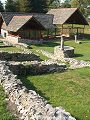
The county town, aptly located near the heart of the county. It is believed that the town was originally founded in 80AD as the only Roman town in Dorset, possibly on or near the site of a garrison fort, no trace of the fort has been found to date. People were however already living in this area from well before that date, evidence of these former inhabitants can be found all around – from the late Neolithic henge of Maumbury Rings (c. 2500BC) just south of the town centre, to the massive Iron Age hillfort Maiden Castle.

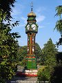
The town limits were, until around the start of the 19th century, demarked by the line of the former Roman town walls. The compact street pattern within this enclosure largely still remains, as a grid like pattern of small intersecting streets and alleyways. The historical importance of the town as administrative centre of the county is evidenced throughout. The views of the town shown here were taken on a typically autumnal day in late September.


094-01 Dorchester 094-02 Dorchester 094-03 Dorchester 094-04 Dorchester 094-05 Dorchester
094-06 Dorchester 094-07 Dorchester 094-08 Dorchester 094-09 Dorchester 094-10 Dorchester
094-11 Dorchester 094-12 Dorchester 094-13 Dorchester 094-14 Dorchester 094-15 Dorchester
To view any image full size - simply click on the thumbnail
  

Find out more ...

In the top row of pictures:

  • The view up East Street towards St Peters and the Town Hall (picture)
  • Corn Exchange and Town Hall, built 1847–8, designed by Benjamin Ferrey (picture)
  • Church of St Peter, at the junction of East, South, West and North Streets (picture)
  • Just one example of the main fine buildings to be found along West Street (picture)
  • Looking northwards along what is now the main shopping street – South Street – by Nappers Court (picture)

In the middle row of pictures:

  • Roman town house, Colliton Park, the only complete Roman town-house visible in Britain (picture)
  • Wollaston Road, example of the style of decorative brickwork used in many of the buildings throughout the town (picture)
  • The Keep Military Museum, monumental gate-house built 1876 (picture)
  • Ornamental clock tower situated in the public park, presented to the borough of Dorchester in 1905 by Charles Hansford (picture)
  • Small shops and alleyways to the rear of the old coaching inn on South Street, The Antelope (picture)

In the bottom row of pictures:

  • Statue of William Barnes (1801–1886) Dorset poet, by Roscoe Mullins, located outside St Peters (picture)
  • South Walks, the walks follow the line of the former Roman town walls (picture)
  • Sculpture by Elizabeth Frink in memory of the religious martyrs of the 16th and 17th Centuries executed at this spot (picture)
  • Hangmans Cottage, outside the old town walls at the north-west corner of the town (picture)
  • Statue of Thomas Hardy (1840–1928) writer and poet, by Eric Kennington. Born a short distance east of Dorchester, Hardy spent much of his life living and working in the town (picture)

Nearby locations that also feature in galleries on this site:

directionPlush and Dorsetshire Gap, Evershot, Cerne Abbas

directionTolpuddle and Puddletown, Moreton and Wool

directionWeymouth

directionFrampton and Bradford Peverell, Upwey, Bride valley

More views of Dorset in September


Other sites on the web

The Dorset Page:   Dorchester – local information and links to further resources on the web

Maps of the area on streetmap.co.uk:   1:50,000 – detail, 1:250,000 – locality and route to get there

picture resolution
The pictures of Dorchester in this gallery were captured at high resolution.
This is images of dorset stock photography gallery 094
All photographs copyright © 1998–2003 John Allen


top of page