Search:
Bere Regis
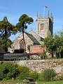
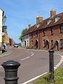
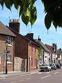
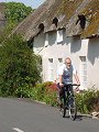
Originally located on the main road linking east and west Dorset, now bypassed, Bere Regis sits on gently undulating hills at the boundary between chalk downlands to the north and sandy heathlands to the south. The focus of the village is the Church of St John the Baptist, probably one of the most visited churches in Dorset thanks to its magnificent timber roof c.1475. The main street is mostly post 1788, Bere Regis being also a victim of one of the fires that plagued Dorset villages sporadically during the 18th century (Blandford 1731, Wareham 1762, etc.)
|
|
|
|
|
|
|
|
|
|
|
To view any image full size - simply click on the thumbnail
| ||||
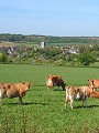
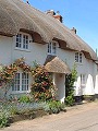
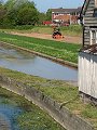
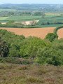
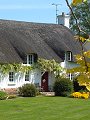
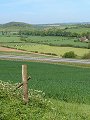
The pictures show the village and surrounding area on a fine mid-May day and were taken during a short (7km) circular walk that first sets off southwards past the watercress beds in the valley bottom – the streams running off the chalk being particularly clean and sediment free – across the sandy heathland on Black Hill and over into the Piddle Valley. Briantspuddle (SY 818 932) is typical of the settlements in the Piddle valley, small with modest sized dwellings. The route then turns northwards onto Kite Hill (SY 821 945) from where there are excellent views to the west and north, before returning the short distance to Bere Regis.
Find out more ... |
|
In the top row of pictures:
In the bottom row of pictures:
Nearby locations that also feature in galleries on this site: More views of Dorset in May Other sites on the webThe Bere Regis Village Website: A well illustrated guide to the village, run in-conjunction with the Bere Regis & Affpuddle Parish Magazine The Dorset Page: Bere Regis, Briantspuddle – local information and links to further resources on the web Maps of the area on streetmap.co.uk: 1:50,000 – detail, 1:250,000 – locality and route to get there
|