
Search:
Isle of Portland
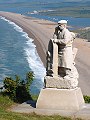
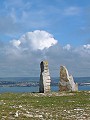
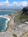
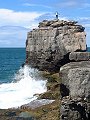
The Isle of Portland is a large sloping block of limestone connected to the mainland by the shingle bank of Chesil Beach (this geographical feature is termed a tombolo). At its highest point – at the northern end – the Isle reaches some 140m above sea-level, from where the land slopes southwards reaching sea-level at the southern tip – Portland Bill.
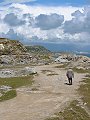
The pale grey limestone quarried from the Isle has been prized for its decorative use in buildings for centuries. St Paul's Cathedral, most of Whitehall and several of the national museums in London are faced with Portland stone, as are numerous other significant buildings – both within the UK and abroad. The legacy of worked-out and still working quarries dominate the landscape.
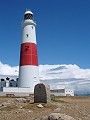
Strong tidal currents flow past the southern tip of the Isle, these – combined with submerged rocks – made this part of the coast particularly hazardous to shipping. Standing on the open ground above Portland Bill are several lighthouses, a prominent reminder of the maritime dangers near-by.
|
|

|
|
|
|
|
|
|

|
|
To view any image full size - simply click on the thumbnail
| ||||
The views of Portland seen here were taken in May, the weather forecast for the day – 'Early mist clearing, then a mixture of sunshine and showers. Showers heavy and locally thundery. Maximum temperature 15 deg C (59 deg F)' – typical for this time of year.
Find out more ... |
|
In the top row of pictures:
In the bottom row of pictures:
See also: Trinity House sea-mark at Portland Bill Other Portland Bill lighthouses illustrated on this site: The Old Lower Light c.1867 Nearby locations that also feature in galleries on this site: More views of Dorset in May Other sites on the webThe Royal Manor and Isle of Portland: Official (and comprehensive) site for the Isle The Portland Bird Observatory: housed in the Old Lower Light The coastline shown here forms part of the Jurassic Coast World Heritage Site West's Geology Field Guide to the Portland area Maps of the area on streetmap.co.uk: 1:50,000 – detail, 1:250,000 – locality and route to get there
|